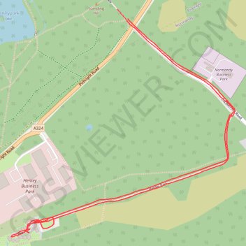
Henley Park
- Distance: 3.7 Km
- Elevation gain: 27 m
- Maximum elevation: 62 m
- Elevation loss: 26 m
- Minimum elevation: 43 m
- Moving time: 19 m 11 s
- Moving speed: 11.5 Km/h
- Maximum speed: 15.9 Km/h
- Total time: 19 m 11 s
- Global speed: 11.5 Km/h
Interactive trail map
Trail profile
- Distance: 3.7 Km
- Elevation gain: 27 m
- Maximum elevation: 62 m
- Elevation loss: 26 m
- Minimum elevation: 43 m
- Moving time: 19 m 11 s
- Moving speed: 11.5 Km/h
- Maximum speed: 15.9 Km/h
- Total time: 19 m 11 s
- Global speed: 11.5 Km/h
About this trail
Name: Henley Park trail, distance, elevation, map, profile, GPS track
Start: Henley Gate, Pirbright, Guildford, Surrey, England, GU24 0DH, United Kingdom (51.27372 -0.65506)
End: Henley Gate, Pirbright, Guildford, Surrey, England, GU24 0DH, United Kingdom (51.27405 -0.65565)
Coordinates: 51.26605 -0.66162 51.27405 -0.64904