Corinth Reservoir
- Distance: 7.0 Km
- Elevation gain: 206 m
- Maximum elevation: 398 m
- Elevation loss: 207 m
- Minimum elevation: 253 m
- Moving time: 1 h 42 m
- Moving speed: 4.1 Km/h
- Maximum speed: 13.6 Km/h
- Total time: 1 h 47 m
- Global speed: 3.9 Km/h
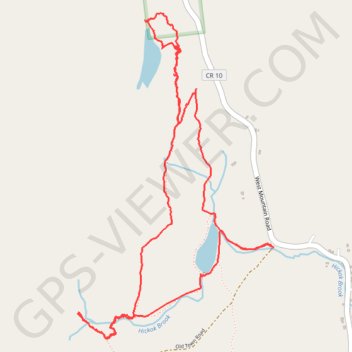
Interactive trail map
Trail profile
- Distance: 7.0 Km
- Elevation gain: 206 m
- Maximum elevation: 398 m
- Elevation loss: 207 m
- Minimum elevation: 253 m
- Moving time: 1 h 42 m
- Moving speed: 4.1 Km/h
- Maximum speed: 13.6 Km/h
- Total time: 1 h 47 m
- Global speed: 3.9 Km/h
About this trail
Name: Corinth Reservoir trail, distance, elevation, map, profile, GPS track
Start: Old Town Road, Town of Corinth, Saratoga County, New York, 12822, United States (43.25060 -73.86259)
End: Old Town Road, Town of Corinth, Saratoga County, New York, 12822, United States (43.25058 -73.86234)
Coordinates: 43.24603 -73.87571 43.26219 -73.86234
Other hiking, mountain biking, running and outdoor activity trails
Click on a trail to view its statistics, map and profile.