Import a GPX file

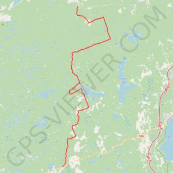
Old Nipissing Ghost Trail

#Bike #Nipissing

  • Distance: 49.6 Km
  • Elevation gain: 562 m
  • Maximum elevation: 386 m
  • Elevation loss: 540 m
  • Minimum elevation: 271 m

Interactive trail map

Trail profile

  • Distance: 49.6 Km
  • Elevation gain: 562 m
  • Maximum elevation: 386 m
  • Elevation loss: 540 m
  • Minimum elevation: 271 m

About this trail

Other hiking, mountain biking, running and outdoor activity trails

Click on a trail to view its statistics, map and profile.

Québec - Montréal - Saint-Laurent River - Lake Ontario - Niagara Falls

Canada > Quebec > Urban agglomeration of Québec > Quebec

#Bike #Ontario

Distance: 1,078.4 Km • Elevation gain: 4,804 m • Maximum elevation: 209 m

Gear up for your next adventure:

🎧Bluetooth Outdoor Earbuds - Listen to navigation cues or podcasts during long solo treks
🏕️Camping Gear - Essential camping equipment
🛌Compact Down Sleeping Bags - Warmth without the bulk, ideal for backcountry camping
🕯️Emergency Whistles - Safety whistles for hiking
🚴Bike GPS - GPS devices for cycling

As an Amazon Associate, this site earns from qualifying purchases at no extra cost to you.