Thank you for supporting this site ❤️
Make a donation
Make a donation
Gear up for your next adventure:
As an Amazon Associate, this site earns from qualifying purchases at no extra cost to you.
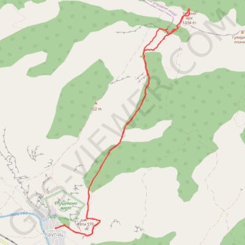
Trenutna trasa: 13 SRP 2019 13:42
- Distance: 12.5 Km
- Elevation gain: 1,123 m
- Maximum elevation: 1,324 m
- Elevation loss: 1,123 m
- Minimum elevation: 273 m
- Moving time: 4 h 24 m
- Moving speed: 2.8 Km/h
- Maximum speed: 7.3 Km/h
- Total time: 5 h 4 m
- Global speed: 2.5 Km/h
Interactive trail map
Thank you for supporting this site ❤️
Make a donation
Make a donation
Gear up for your next adventure:
As an Amazon Associate, this site earns from qualifying purchases at no extra cost to you.
Trail profile
- Distance: 12.5 Km
- Elevation gain: 1,123 m
- Maximum elevation: 1,324 m
- Elevation loss: 1,123 m
- Minimum elevation: 273 m
- Moving time: 4 h 24 m
- Moving speed: 2.8 Km/h
- Maximum speed: 7.3 Km/h
- Total time: 5 h 4 m
- Global speed: 2.5 Km/h
Thank you for supporting this site ❤️
Make a donation
Make a donation
Gear up for your next adventure:
As an Amazon Associate, this site earns from qualifying purchases at no extra cost to you.
About this trail
Name: Trenutna trasa: 13 SRP 2019 13:42 trail, distance, elevation, map, profile, GPS track
Coordinates: 43.29398 22.22344 43.33044 22.25308
Thank you for supporting this site ❤️
Make a donation
Make a donation
Gear up for your next adventure:
As an Amazon Associate, this site earns from qualifying purchases at no extra cost to you.