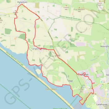
Portesham to Weymouth loop
- Distance: 25.6 Km
- Elevation gain: 319 m
- Maximum elevation: 82 m
- Elevation loss: 318 m
- Minimum elevation: -2 m
Interactive trail map
Trail profile
- Distance: 25.6 Km
- Elevation gain: 319 m
- Maximum elevation: 82 m
- Elevation loss: 318 m
- Minimum elevation: -2 m
About this trail
Name: Portesham to Weymouth loop trail, distance, elevation, map, profile, GPS track
Start: Kings Arms, Bramdon Lane, Portesham, Dorset, England, DT3 4LX, United Kingdom (50.66876 -2.56431)
End: Bramdon Lane, Portesham, Dorset, England, DT3 4LX, United Kingdom (50.66869 -2.56365)
Coordinates: 50.60522 -2.57264 50.66937 -2.49201
Other hiking, mountain biking, running and outdoor activity trails
Click on a trail to view its statistics, map and profile.
West Bexington to Portisham Loop
United Kingdom > England > Dorset > West Bexington
Distance: 21.4 Km • Elevation gain: 352 m • Maximum elevation: 184 m
Osmington loop
United Kingdom > England > Dorset > Osmington
West Dorset Road Cycling
Distance: 38.1 Km • Elevation gain: 554 m • Maximum elevation: 209 m