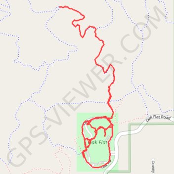
Oak Flat
- Distance: 5.7 Km
- Elevation gain: 102 m
- Maximum elevation: 2,349 m
- Elevation loss: 37 m
- Minimum elevation: 2,274 m
Interactive trail map
Trail profile
- Distance: 5.7 Km
- Elevation gain: 102 m
- Maximum elevation: 2,349 m
- Elevation loss: 37 m
- Minimum elevation: 2,274 m
About this trail
Name: Oak Flat trail, distance, elevation, map, profile, GPS track
Start: Gambel Oak, Bernalillo County, New Mexico, United States (35.00810 -106.32494)
End: Oak Flat Connector, Bernalillo County, New Mexico, United States (34.99623 -106.32271)
Coordinates: 34.99541 -106.32500 35.00813 -106.31972
Other hiking, mountain biking, running and outdoor activity trails
Click on a trail to view its statistics, map and profile.
Oak Flat loop via Mahogany, Easy Pikin', Pine Loop and Gambel Oak in the Cibola National Forest
United States > New Mexico > Bernalillo County
Distance: 10.5 Km • Elevation gain: 150 m • Maximum elevation: 2,347 m
Loop Trails from Pine Flat via Poker Chip, Mahogany, Oak Flat, Sofa Queen and Deadman
United States > New Mexico > Bernalillo County > Tijeras > Cedro
Distance: 16.0 Km • Elevation gain: 245 m • Maximum elevation: 2,343 m
Pine Flats
United States > New Mexico > Bernalillo County
Distance: 30.8 Km • Elevation gain: 493 m • Maximum elevation: 2,343 m