Import a GPX file

Riverside disc course

Martha McLean-Anza Narrows Park loop

  • Distance: 3.1 Km
  • Elevation gain: 34 m
  • Maximum elevation: 240 m
  • Elevation loss: 35 m
  • Minimum elevation: 224 m
  • Moving time: 36 m 38 s
  • Moving speed: 5.0 Km/h
  • Maximum speed: 7.1 Km/h
  • Total time: 36 m 38 s
  • Global speed: 5.0 Km/h

Interactive trail map

Trail profile

  • Distance: 3.1 Km
  • Elevation gain: 34 m
  • Maximum elevation: 240 m
  • Elevation loss: 35 m
  • Minimum elevation: 224 m
  • Moving time: 36 m 38 s
  • Moving speed: 5.0 Km/h
  • Maximum speed: 7.1 Km/h
  • Total time: 36 m 38 s
  • Global speed: 5.0 Km/h

About this trail
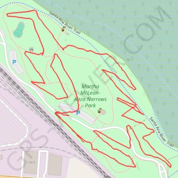
Name: Riverside disc course trail, distance, elevation, map, profile, GPS track

Start: Santa Ana River Trail, Riverside, Riverside County, California, 92504, United States (33.96446 -117.43054)

End: Santa Ana River Trail, Riverside, Riverside County, California, 92504, United States (33.96380 -117.43008)

Coordinates: 33.96316 -117.43242 33.96710 -117.42745

Gear up for your next adventure:

🥤Hydration Packs - Hydration systems for hiking
🎽Hiking Clothing - Breathable clothing for hiking
🏫Topographic World Globes - 3D physical relief globes to understand global geography
🛰️Handheld GPS Units - Rugged GPS devices for tracking coordinates and elevation in the Australian bush
🥾Hiking Boots - Durable hiking boots for trails and rough terrain

As an Amazon Associate, this site earns from qualifying purchases at no extra cost to you.