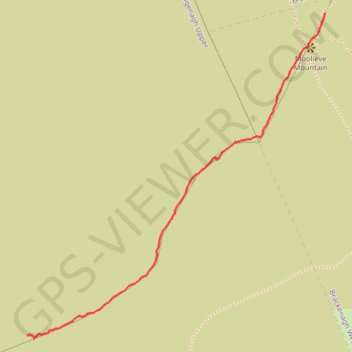
Moolieve Mountain
- Distance: 0.9 Km
- Elevation gain: 138 m
- Maximum elevation: 330 m
- Elevation loss: 45 m
- Minimum elevation: 192 m
- Moving time: 21 m 36 s
- Moving speed: 2.6 Km/h
- Maximum speed: 5.5 Km/h
- Total time: 31 m 22 s
- Global speed: 1.8 Km/h
Interactive trail map
Trail profile
- Distance: 0.9 Km
- Elevation gain: 138 m
- Maximum elevation: 330 m
- Elevation loss: 45 m
- Minimum elevation: 192 m
- Moving time: 21 m 36 s
- Moving speed: 2.6 Km/h
- Maximum speed: 5.5 Km/h
- Total time: 31 m 22 s
- Global speed: 1.8 Km/h
About this trail
Name: Moolieve Mountain trail, distance, elevation, map, profile, GPS track
Start: Head Road, County Down, Northern Ireland, BT34 4JA, United Kingdom (54.12590 -5.99770)
Coordinates: 54.12584 -5.99770 54.13133 -5.98913