Make a donation
Gear up for your next adventure:
As an Amazon Associate, this site earns from qualifying purchases at no extra cost to you.
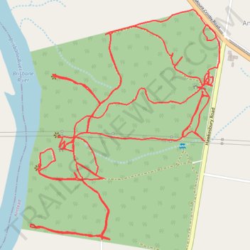
Anstead Bushland Reserve
- Distance: 10.2 Km
- Elevation gain: 206 m
- Maximum elevation: 65 m
- Elevation loss: 207 m
- Minimum elevation: 17 m
- Moving time: 1 h 32 m
- Moving speed: 6.6 Km/h
- Maximum speed: 11.4 Km/h
- Total time: 1 h 43 m
- Global speed: 5.9 Km/h
Interactive trail map
Make a donation
Gear up for your next adventure:
As an Amazon Associate, this site earns from qualifying purchases at no extra cost to you.
Trail profile
- Distance: 10.2 Km
- Elevation gain: 206 m
- Maximum elevation: 65 m
- Elevation loss: 207 m
- Minimum elevation: 17 m
- Moving time: 1 h 32 m
- Moving speed: 6.6 Km/h
- Maximum speed: 11.4 Km/h
- Total time: 1 h 43 m
- Global speed: 5.9 Km/h
Make a donation
Gear up for your next adventure:
As an Amazon Associate, this site earns from qualifying purchases at no extra cost to you.
About this trail
Name: Anstead Bushland Reserve trail, distance, elevation, map, profile, GPS track
Start: Hawkesbury Road, Anstead, Greater Brisbane, Queensland, 4070, Australia (-27.54297 152.86152)
End: Hawkesbury Road, Anstead, Greater Brisbane, Queensland, 4070, Australia (-27.54278 152.86171)
Coordinates: -27.54968 152.85313 -27.53991 152.86215
Topography: Queensland topographic map, elevation, terrain
Make a donation
Gear up for your next adventure:
As an Amazon Associate, this site earns from qualifying purchases at no extra cost to you.
Other hiking, mountain biking, running and outdoor activity trails
Click on a trail to view its statistics, map and profile.