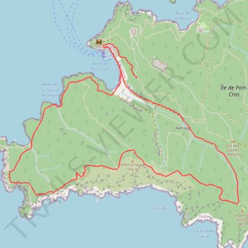
PORT-CROS, BOUCLE SUD-OUEST
- Distance: 8.4 Km
- Elevation gain: 385 m
- Maximum elevation: 172 m
- Elevation loss: 384 m
- Minimum elevation: 0 m
- Moving time: 2 h 46 m
- Moving speed: 3.0 Km/h
- Maximum speed: 3.2 Km/h
- Total time: 2 h 46 m
- Global speed: 3.0 Km/h
Interactive trail map
Trail profile
- Distance: 8.4 Km
- Elevation gain: 385 m
- Maximum elevation: 172 m
- Elevation loss: 384 m
- Minimum elevation: 0 m
- Moving time: 2 h 46 m
- Moving speed: 3.0 Km/h
- Maximum speed: 3.2 Km/h
- Total time: 2 h 46 m
- Global speed: 3.0 Km/h
About this trail
Name: PORT-CROS, BOUCLE SUD-OUEST trail, distance, elevation, map, profile, GPS track
Coordinates: 42.99689 6.37083 43.01040 6.39730
Other hiking, mountain biking, running and outdoor activity trails
Click on a trail to view its statistics, map and profile.
1 LUCENA - MONTPELLIER
Distance: 2,964.4 Km • Elevation gain: 29,500 m • Maximum elevation: 1,048 m
PT23DS2 Lörrach → Cadaqués
Germany > Baden-Württemberg > Landkreis Lörrach > Lörrach (Kernstadt)
Distance: 1,050.7 Km • Elevation gain: 13,130 m • Maximum elevation: 1,505 m
PORT-CROS, BOUCLE NORD-EST
France > Provence-Alpes-Côte d'Azur > Var > Hyères > Port-Cros
Distance: 10.5 Km • Elevation gain: 531 m • Maximum elevation: 190 m