Import a GPX file

Walk back and forth on a section of the Kildaire Farms Greenway Trail

  • Distance: 2.5 Km
  • Elevation gain: 21 m
  • Maximum elevation: 128 m
  • Elevation loss: 21 m
  • Minimum elevation: 113 m
  • Moving time: 24 m 33 s
  • Moving speed: 6.1 Km/h
  • Maximum speed: 40.8 Km/h
  • Total time: 25 m 36 s
  • Global speed: 5.8 Km/h

Interactive trail map

Trail profile

  • Distance: 2.5 Km
  • Elevation gain: 21 m
  • Maximum elevation: 128 m
  • Elevation loss: 21 m
  • Minimum elevation: 113 m
  • Moving time: 24 m 33 s
  • Moving speed: 6.1 Km/h
  • Maximum speed: 40.8 Km/h
  • Total time: 25 m 36 s
  • Global speed: 5.8 Km/h

About this trail
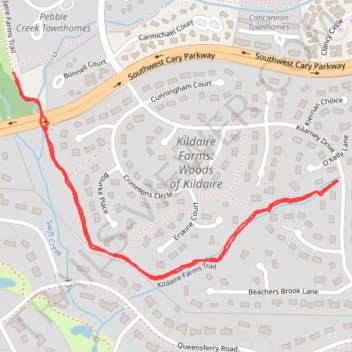
Name: Walk back and forth on a section of the Kildaire Farms Greenway Trail trail, distance, elevation, map, profile, GPS track

Start: Kildaire Farms Trail, Kildaire Farms: Woods of Kildaire, Cary, Wake County, North Carolina, 27511, United States (35.75464 -78.78704)

End: Kildaire Farms Trail, Kildaire Farms: Woods of Kildaire, Cary, Wake County, North Carolina, 27511, United States (35.75461 -78.78706)

Coordinates: 35.75246 -78.79591 35.75703 -78.78704

Gear up for your next adventure:

🛌Compact Down Sleeping Bags - Warmth without the bulk, ideal for backcountry camping
🔪Camping Knives - Multi-purpose outdoor knives
👣Snake & Scrub Gaiters - Protection against spinifex, mud, and snakes while walking off-track
🎨Portable Watercolor Kits - Paint the landscapes and topographic views you discover
🥤Outdoor Water Bottles - Reusable bottles for outdoor activities

As an Amazon Associate, this site earns from qualifying purchases at no extra cost to you.