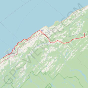
Rimouski - Sayabec
Saint Lawrence River. #Bike #Rimouski #Sayabec #SaintLawrence
- Distance: 85.1 Km
- Elevation gain: 686 m
- Maximum elevation: 296 m
- Elevation loss: 502 m
- Minimum elevation: 0 m
Interactive trail map
Trail profile
- Distance: 85.1 Km
- Elevation gain: 686 m
- Maximum elevation: 296 m
- Elevation loss: 502 m
- Minimum elevation: 0 m
About this trail
Name: Rimouski - Sayabec trail, distance, elevation, map, profile, GPS track
Coordinates: 48.41732 -68.61287 48.61089 -67.75197
Other hiking, mountain biking, running and outdoor activity trails
Click on a trail to view its statistics, map and profile.
Rivière-du-Loup - Rimouski
Canada > Quebec > Rivière-du-Loup (MRC) > Rivière-du-Loup
Saint Lawrence River. #Bike #RivièreDuLoup #Rimouski #SaintLawrence
Distance: 100.5 Km • Elevation gain: 533 m • Maximum elevation: 121 m
Sayabec - Causapscal
Canada > Quebec > La Matapédia > Sayabec
Lake Matapédia. #Bike #Sayabec #Causapscal #Matapédia
Distance: 52.6 Km • Elevation gain: 345 m • Maximum elevation: 266 m
Rimouski - Matane
Canada > Quebec > Rimouski-Neigette > Rimouski > L'Anse-au-Sable
Saint Lawrence River. #Bike #Rimouski #Matane #SaintLawrence
Distance: 104.5 Km • Elevation gain: 485 m • Maximum elevation: 58 m