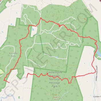
Castlemaine Diggins Park and Kalimns Park Loop
Loop hike via Pikestreet Road, The Folly Track, Welsh Street, Forest Creek Track, Expedition Pass Reservoir, Nicholson Extension Track, No 1 Remote Track, Haws No 1 Track, North West Break and Unknown Miners Grave in the Castlemaine Diggins National Heritage Park and the Kalimns Park. #Hiking #Loop #Nature #Park #Forest #Lake
- Distance: 11.7 Km
- Elevation gain: 256 m
- Maximum elevation: 433 m
- Elevation loss: 265 m
- Minimum elevation: 304 m
Interactive trail map
Trail profile
- Distance: 11.7 Km
- Elevation gain: 256 m
- Maximum elevation: 433 m
- Elevation loss: 265 m
- Minimum elevation: 304 m
About this trail
Name: Castlemaine Diggins Park and Kalimns Park Loop trail, distance, elevation, map, profile, GPS track
Coordinates: -37.06224 144.23343 -37.03925 144.27443
Topography: Victoria topographic map, elevation, terrain
Other hiking, mountain biking, running and outdoor activity trails
Click on a trail to view its statistics, map and profile.
Garfield Water Wheel, Garfield mine, Quartz Hill and Goldfields track walk
Distance: 9.9 Km • Elevation gain: 261 m • Maximum elevation: 413 m
Specimen Gully, Pineys, Golden Point Res, Garfield Water Wheel, Chewton, Castlemaine, Botanic gardens walk
Distance: 18.3 Km • Elevation gain: 269 m • Maximum elevation: 468 m