Import a GPX file

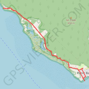
Picnic Bay - West Point

Magnetic Island National Park. #MTB #Magnetic

  • Distance: 18.5 Km
  • Elevation gain: 150 m
  • Maximum elevation: 32 m
  • Elevation loss: 150 m
  • Minimum elevation: 0 m

Interactive trail map

Trail profile

  • Distance: 18.5 Km
  • Elevation gain: 150 m
  • Maximum elevation: 32 m
  • Elevation loss: 150 m
  • Minimum elevation: 0 m

About this trail

Other hiking, mountain biking, running and outdoor activity trails

Click on a trail to view its statistics, map and profile.

Hawkings Point

Australia > Queensland > Townsville

Magnetic Island National Park. #Hiking #Loop #Magnetic

Distance: 5.7 Km • Elevation gain: 103 m • Maximum elevation: 72 m

Gear up for your next adventure:

🩹Blister Prevention Tape - Apply to friction points before they become painful sores
🔌Fast Charging Adapters - Quickly top up all your gear before heading back into the field
📱Shockproof Phone Cases - Extra protection for your smartphone against drops on rocky terrain
🐍Snake Gaiters - Protection against snake bites
🧺Waterproof Dry Sacks - Organize your pack and keep electronics safe from rain and river crossings

As an Amazon Associate, this site earns from qualifying purchases at no extra cost to you.