Make a donation
Gear up for your next adventure:
As an Amazon Associate, this site earns from qualifying purchases at no extra cost to you.
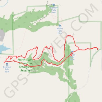
North Table Mountain Loop
Loop hike in North Table Mountain Ecological Reserve via Hollow Falls. #Hiking #Loop #Nature #Mountain #Forest
- Distance: 11.9 Km
- Elevation gain: 259 m
- Maximum elevation: 409 m
- Elevation loss: 259 m
- Minimum elevation: 279 m
- Moving time: 4 h 17 m
- Moving speed: 2.8 Km/h
- Maximum speed: 5.0 Km/h
- Total time: 9 h 10 m
- Global speed: 1.3 Km/h
Interactive trail map
Make a donation
Gear up for your next adventure:
As an Amazon Associate, this site earns from qualifying purchases at no extra cost to you.
Trail profile
- Distance: 11.9 Km
- Elevation gain: 259 m
- Maximum elevation: 409 m
- Elevation loss: 259 m
- Minimum elevation: 279 m
- Moving time: 4 h 17 m
- Moving speed: 2.8 Km/h
- Maximum speed: 5.0 Km/h
- Total time: 9 h 10 m
- Global speed: 1.3 Km/h
Make a donation
Gear up for your next adventure:
As an Amazon Associate, this site earns from qualifying purchases at no extra cost to you.
About this trail
Name: North Table Mountain Loop trail, distance, elevation, map, profile, GPS track
Coordinates: 39.59000 -121.58231 39.60028 -121.54154
Make a donation
Gear up for your next adventure:
As an Amazon Associate, this site earns from qualifying purchases at no extra cost to you.
Other hiking, mountain biking, running and outdoor activity trails
Click on a trail to view its statistics, map and profile.
Phantom Falls Trail in North Table Mountain Ecological Preserve
United States > California > Butte County > Cherokee
The Phantom Falls Trail offers a rewarding hike through rolling hills, vibrant wildflower meadows, and unique basalt rock formations. As you journey across the open landscape, seasonal vernal pools and grazing cattle add to the rustic charm. The trail culminates at Phantom Falls, a dramatic cascade plunging…
Distance: 6.2 Km • Elevation gain: 149 m • Maximum elevation: 409 m