Make a donation
Gear up for your next adventure:
As an Amazon Associate, this site earns from qualifying purchases at no extra cost to you.
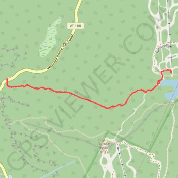
Sterling Pond Trail and Top of the Notch in Mount Mansfield State Forest
The Sterling Pond Trail offers an engaging hike through a varied landscape. Along the way, hikers are treated to a rich diversity of plant life, especially as they pass into the cool, high-elevation spruce-fir forests. At Sterling Pond itself, the scenery is spectacular, with expansive views across the water toward the Madonna Peak ridge. For a more extended adventure, hikers can continue along the Long Trail which offers additional viewpoints and connects with routes leading to the Top of the Notch. This higher point grants sweeping vistas of Mount Mansfield and the surrounding mountain ranges. #Hiking #Mountain #Lake #Overlook #Forest #Nature
- Distance: 4.0 Km
- Elevation gain: 284 m
- Maximum elevation: 928 m
- Elevation loss: 283 m
- Minimum elevation: 649 m
- Moving time: 1 h 51 m
- Moving speed: 2.2 Km/h
- Maximum speed: 6.9 Km/h
- Total time: 2 h 26 m
- Global speed: 1.6 Km/h
Interactive trail map
Make a donation
Gear up for your next adventure:
As an Amazon Associate, this site earns from qualifying purchases at no extra cost to you.
Trail profile
- Distance: 4.0 Km
- Elevation gain: 284 m
- Maximum elevation: 928 m
- Elevation loss: 283 m
- Minimum elevation: 649 m
- Moving time: 1 h 51 m
- Moving speed: 2.2 Km/h
- Maximum speed: 6.9 Km/h
- Total time: 2 h 26 m
- Global speed: 1.6 Km/h
Make a donation
Gear up for your next adventure:
As an Amazon Associate, this site earns from qualifying purchases at no extra cost to you.
About this trail
Name: Sterling Pond Trail and Top of the Notch in Mount Mansfield State Forest trail, distance, elevation, map, profile, GPS track
Start: Vermont Route 108 South, Cambridge, Lamoille County, Vermont, United States (44.55676 -72.79419)
End: Vermont Route 108 South, Cambridge, Lamoille County, Vermont, United States (44.55673 -72.79415)
Coordinates: 44.55429 -72.79421 44.55752 -72.77499
Make a donation
Gear up for your next adventure:
As an Amazon Associate, this site earns from qualifying purchases at no extra cost to you.
Other hiking, mountain biking, running and outdoor activity trails
Click on a trail to view its statistics, map and profile.