Huxham Woods
- Distance: 1.8 Km
- Elevation gain: 40 m
- Maximum elevation: 118 m
- Elevation loss: 42 m
- Minimum elevation: 78 m
- Moving time: 35 m 26 s
- Moving speed: 3.0 Km/h
- Maximum speed: 5.9 Km/h
- Total time: 50 m 39 s
- Global speed: 2.1 Km/h
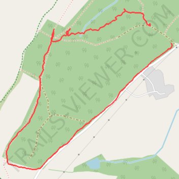
Interactive trail map
Trail profile
- Distance: 1.8 Km
- Elevation gain: 40 m
- Maximum elevation: 118 m
- Elevation loss: 42 m
- Minimum elevation: 78 m
- Moving time: 35 m 26 s
- Moving speed: 3.0 Km/h
- Maximum speed: 5.9 Km/h
- Total time: 50 m 39 s
- Global speed: 2.1 Km/h
About this trail
Name: Huxham Woods trail, distance, elevation, map, profile, GPS track
Start: Huxham, East Devon, Devon, Devon and Torbay, England, EX4 0AA, United Kingdom (50.76128 -3.49682)
End: Huxham, East Devon, Devon, Devon and Torbay, England, EX4 0AA, United Kingdom (50.76076 -3.49581)
Coordinates: 50.75695 -3.50369 50.76179 -3.49578