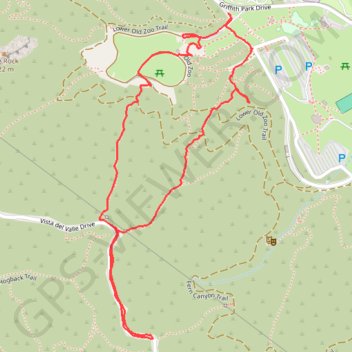
Griffith Park, Old Zoo Area
Interactive trail map
Trail profile
- Distance: 3.0 Km
- Elevation gain: 205 m
- Maximum elevation: 343 m
- Elevation loss: 205 m
- Minimum elevation: 154 m
- Moving time: 47 m 22 s
- Moving speed: 3.8 Km/h
- Maximum speed: 9.9 Km/h
- Total time: 50 m 12 s
- Global speed: 3.6 Km/h
About this trail
Name: Griffith Park, Old Zoo Area trail, distance, elevation, map, profile, GPS track
Coordinates: 34.12704 -118.29053 34.13542 -118.28579
Other hiking, mountain biking, running and outdoor activity trails
Click on a trail to view its statistics, map and profile.
Tom LaBonge Panorama via Bill Eckert Trail and North Trail in Griffith Park
United States > California > Los Angeles County > Los Angeles
This trail to Tom LaBonge Panorama offers a moderately challenging hike in Griffith Park, winding through scenic vistas with views of Mount Hollywood, Taco Peak, and the iconic Hollywood Sign. The trail provides a rewarding panoramic perspective of Los Angeles, including landmarks like the Griffith Park Old…
Distance: 9.9 Km • Elevation gain: 461 m • Maximum elevation: 478 m
Glendale Peak and Mount Hollywood Loop via Riverside, Hogback, and Mount Hollywood Trails in Griffith Park
United States > California > Los Angeles County > Los Angeles
The Glendale Peak and Mount Hollywood Loop in Griffith Park offers hikers panoramic views of Los Angeles, including the Griffith Observatory, the Hollywood Sign, and the downtown skyline. The trail traverses diverse landscapes, from shaded paths to open ridges, providing a varied hiking experience. Along the…
Distance: 5.4 Km • Elevation gain: 273 m • Maximum elevation: 458 m