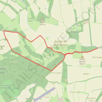
Farley Mount track
- Distance: 6.4 Km
- Elevation gain: 141 m
- Maximum elevation: 172 m
- Elevation loss: 115 m
- Minimum elevation: 83 m
- Moving time: 1 h 19 m
- Moving speed: 4.8 Km/h
- Maximum speed: 40.6 Km/h
- Total time: 1 h 20 m
- Global speed: 4.8 Km/h
Interactive trail map
Trail profile
- Distance: 6.4 Km
- Elevation gain: 141 m
- Maximum elevation: 172 m
- Elevation loss: 115 m
- Minimum elevation: 83 m
- Moving time: 1 h 19 m
- Moving speed: 4.8 Km/h
- Maximum speed: 40.6 Km/h
- Total time: 1 h 20 m
- Global speed: 4.8 Km/h
About this trail
Name: Farley Mount track trail, distance, elevation, map, profile, GPS track
Start: Ashley, Test Valley, Hampshire, England, SO20 6RL, United Kingdom (51.06191 -1.41924)
Coordinates: 51.05546 -1.46036 51.06641 -1.41924