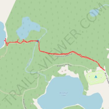
Hiking Lost-Glacier Lakes Trail
- Distance: 2.6 Km
- Elevation gain: 71 m
- Maximum elevation: 3,291 m
- Elevation loss: 71 m
- Minimum elevation: 3,225 m
- Moving time: 1 h 13 m
- Moving speed: 2.1 Km/h
- Maximum speed: 4.7 Km/h
- Total time: 1 h 45 m
- Global speed: 1.5 Km/h
Interactive trail map
Trail profile
- Distance: 2.6 Km
- Elevation gain: 71 m
- Maximum elevation: 3,291 m
- Elevation loss: 71 m
- Minimum elevation: 3,225 m
- Moving time: 1 h 13 m
- Moving speed: 2.1 Km/h
- Maximum speed: 4.7 Km/h
- Total time: 1 h 45 m
- Global speed: 1.5 Km/h
About this trail
Name: Hiking Lost-Glacier Lakes Trail trail, distance, elevation, map, profile, GPS track
Start: 158, Brooklyn Lake Road, Albany County, Wyoming, 82055, United States (41.37400 -106.24631)
End: 158, Brooklyn Lake Road, Albany County, Wyoming, 82055, United States (41.37401 -106.24629)
Coordinates: 41.37400 -106.25827 41.37685 -106.24626
Other hiking, mountain biking, running and outdoor activity trails
Click on a trail to view its statistics, map and profile.
Browns Peak via Sheep Lake Trail
United States > Wyoming > Albany County
Distance: 7.2 Km • Elevation gain: 389 m • Maximum elevation: 3,571 m