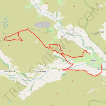
Mountain bike trip from Richmondshire to Grinton via Level House and River Swale
- Distance: 30.5 Km
- Elevation gain: 765 m
- Maximum elevation: 573 m
- Elevation loss: 824 m
- Minimum elevation: 176 m
- Moving time: 3 h 10 m
- Moving speed: 9.6 Km/h
- Maximum speed: 44.0 Km/h
- Total time: 4 h 44 m
- Global speed: 6.4 Km/h
Interactive trail map
Trail profile
- Distance: 30.5 Km
- Elevation gain: 765 m
- Maximum elevation: 573 m
- Elevation loss: 824 m
- Minimum elevation: 176 m
- Moving time: 3 h 10 m
- Moving speed: 9.6 Km/h
- Maximum speed: 44.0 Km/h
- Total time: 4 h 44 m
- Global speed: 6.4 Km/h
About this trail
Name: Mountain bike trip from Richmondshire to Grinton via Level House and River Swale trail, distance, elevation, map, profile, GPS track
Coordinates: 54.37451 -2.08618 54.41778 -1.92935
Other hiking, mountain biking, running and outdoor activity trails
Click on a trail to view its statistics, map and profile.
High Harker Hill Loop from Reeth
United Kingdom > England > North Yorkshire > Reeth > Jenny Hill
Distance: 12.4 Km • Elevation gain: 341 m • Maximum elevation: 464 m