Thank you for supporting this site ❤️
Make a donation
Make a donation
Gear up for your next adventure:
As an Amazon Associate, this site earns from qualifying purchases at no extra cost to you.
La Milagrosa Loop
Loop hike from Hohokam Estates via La Milagrosa in the Coronado National Forest. #Hiking #Loop #Mountain #Nature
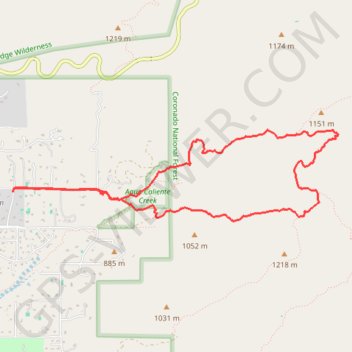
- Distance: 9.9 Km
- Elevation gain: 438 m
- Maximum elevation: 1,143 m
- Elevation loss: 438 m
- Minimum elevation: 848 m
- Moving time: 3 h 3 m
- Moving speed: 3.2 Km/h
- Maximum speed: 5.5 Km/h
- Total time: 3 h 32 m
- Global speed: 2.8 Km/h
Interactive trail map
Thank you for supporting this site ❤️
Make a donation
Make a donation
Gear up for your next adventure:
As an Amazon Associate, this site earns from qualifying purchases at no extra cost to you.
Trail profile
- Distance: 9.9 Km
- Elevation gain: 438 m
- Maximum elevation: 1,143 m
- Elevation loss: 438 m
- Minimum elevation: 848 m
- Moving time: 3 h 3 m
- Moving speed: 3.2 Km/h
- Maximum speed: 5.5 Km/h
- Total time: 3 h 32 m
- Global speed: 2.8 Km/h
Thank you for supporting this site ❤️
Make a donation
Make a donation
Gear up for your next adventure:
🧊Insulated Stainless Steel Flasks - Keep water cold for 24 hours in the heat or coffee hot in the cold
As an Amazon Associate, this site earns from qualifying purchases at no extra cost to you.
About this trail
Name: La Milagrosa Loop trail, distance, elevation, map, profile, GPS track
Coordinates: 32.29509 -110.73076 32.30410 -110.69282
Thank you for supporting this site ❤️
Make a donation
Make a donation
Gear up for your next adventure:
As an Amazon Associate, this site earns from qualifying purchases at no extra cost to you.