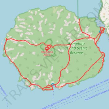
Rangitoto Island
- Distance: 36.9 Km
- Elevation gain: 569 m
- Maximum elevation: 239 m
- Elevation loss: 569 m
- Minimum elevation: 0 m
- Moving time: 4 h 56 m
- Moving speed: 7.5 Km/h
- Maximum speed: 13.1 Km/h
- Total time: 5 h 4 m
- Global speed: 7.3 Km/h
Interactive trail map
Trail profile
- Distance: 36.9 Km
- Elevation gain: 569 m
- Maximum elevation: 239 m
- Elevation loss: 569 m
- Minimum elevation: 0 m
- Moving time: 4 h 56 m
- Moving speed: 7.5 Km/h
- Maximum speed: 13.1 Km/h
- Total time: 5 h 4 m
- Global speed: 7.3 Km/h
About this trail
Name: Rangitoto Island trail, distance, elevation, map, profile, GPS track
Start: Rangitoto Wharf, Kōwhai Grove, Waiheke, Auckland, 1074, New Zealand (-36.80893 174.86237)
End: Rangitoto Wharf, Kōwhai Grove, Waiheke, Auckland, 1074, New Zealand (-36.80882 174.86231)
Coordinates: -36.80896 174.82930 -36.77039 174.89719