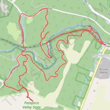
Patapsco State Park - Sykesville/Henryton area
- Distance: 9.3 Km
- Elevation gain: 227 m
- Maximum elevation: 169 m
- Elevation loss: 227 m
- Minimum elevation: 87 m
- Moving time: 1 h 27 m
- Moving speed: 6.4 Km/h
- Maximum speed: 14.5 Km/h
- Total time: 1 h 33 m
- Global speed: 5.9 Km/h
Interactive trail map
Trail profile
- Distance: 9.3 Km
- Elevation gain: 227 m
- Maximum elevation: 169 m
- Elevation loss: 227 m
- Minimum elevation: 87 m
- Moving time: 1 h 27 m
- Moving speed: 6.4 Km/h
- Maximum speed: 14.5 Km/h
- Total time: 1 h 33 m
- Global speed: 5.9 Km/h
About this trail
Name: Patapsco State Park - Sykesville/Henryton area trail, distance, elevation, map, profile, GPS track
Coordinates: 39.34379 -76.91707 39.35677 -76.89886
Other hiking, mountain biking, running and outdoor activity trails
Click on a trail to view its statistics, map and profile.
Patapsco State Park - Sykesville Henryton Area
United States > Maryland > Howard County > Marriottsville
Distance: 13.2 Km • Elevation gain: 228 m • Maximum elevation: 160 m