Make a donation
Gear up for your next adventure:
As an Amazon Associate, this site earns from qualifying purchases at no extra cost to you.
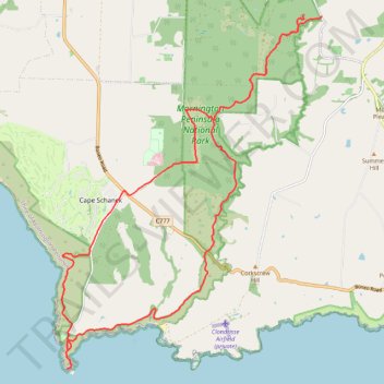
Greens Bush, Mornington Peninsula National Park and Cape schanck loop
- Distance: 30.9 Km
- Elevation gain: 632 m
- Maximum elevation: 178 m
- Elevation loss: 654 m
- Minimum elevation: 0 m
- Moving time: 6 h 9 m
- Moving speed: 5.0 Km/h
- Maximum speed: 15.4 Km/h
- Total time: 6 h 46 m
- Global speed: 4.6 Km/h
Interactive trail map
Make a donation
Gear up for your next adventure:
As an Amazon Associate, this site earns from qualifying purchases at no extra cost to you.
Trail profile
- Distance: 30.9 Km
- Elevation gain: 632 m
- Maximum elevation: 178 m
- Elevation loss: 654 m
- Minimum elevation: 0 m
- Moving time: 6 h 9 m
- Moving speed: 5.0 Km/h
- Maximum speed: 15.4 Km/h
- Total time: 6 h 46 m
- Global speed: 4.6 Km/h
Make a donation
Gear up for your next adventure:
As an Amazon Associate, this site earns from qualifying purchases at no extra cost to you.
About this trail
Name: Greens Bush, Mornington Peninsula National Park and Cape schanck loop trail, distance, elevation, map, profile, GPS track
Coordinates: -38.49961 144.88656 -38.42030 144.96076
Topography: Melbourne topographic map, elevation, terrain
Make a donation
Gear up for your next adventure:
As an Amazon Associate, this site earns from qualifying purchases at no extra cost to you.
Other hiking, mountain biking, running and outdoor activity trails
Click on a trail to view its statistics, map and profile.
Greens Bush - Cape Schanck loop
Australia > Victoria > Melbourne > Cape Schanck
Distance: 18.6 Km • Elevation gain: 462 m • Maximum elevation: 150 m
Cape Schanck - Mornington Peninsula
Australia > Victoria > Melbourne > Cape Schanck
Distance: 8.0 Km • Elevation gain: 324 m • Maximum elevation: 81 m
St Andrews Beach, Boag rocks, Gunnamatta beach, Cape Schanck walk
Australia > Victoria > Melbourne
Distance: 12.7 Km • Elevation gain: 263 m • Maximum elevation: 122 m
Make a donation
Gear up for your next adventure:
As an Amazon Associate, this site earns from qualifying purchases at no extra cost to you.