View of the Temple of the Sun and the Temple of the Moon
Hike on the Lower Cathedral Valley Overlook Route in the Capitol Reef National Park. #Hiking #Overlook #Nature #Rock #Desert #Park
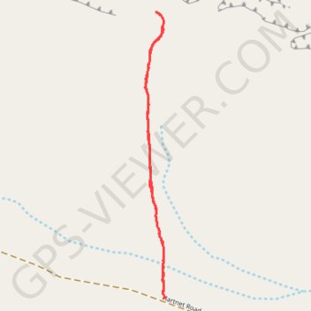
- Distance: 2.8 Km
- Elevation gain: 48 m
- Maximum elevation: 1,819 m
- Elevation loss: 48 m
- Minimum elevation: 1,776 m
- Moving time: 46 m 50 s
- Moving speed: 3.6 Km/h
- Maximum speed: 4.0 Km/h
- Total time: 46 m 50 s
- Global speed: 3.6 Km/h
Interactive trail map
Trail profile
- Distance: 2.8 Km
- Elevation gain: 48 m
- Maximum elevation: 1,819 m
- Elevation loss: 48 m
- Minimum elevation: 1,776 m
- Moving time: 46 m 50 s
- Moving speed: 3.6 Km/h
- Maximum speed: 4.0 Km/h
- Total time: 46 m 50 s
- Global speed: 3.6 Km/h
About this trail
Name: View of the Temple of the Sun and the Temple of the Moon trail, distance, elevation, map, profile, GPS track
Start: Lower Cathedral Valley Overlook Route, Wayne County, Utah, United States (38.43039 -111.20563)
End: Lower Cathedral Valley Overlook Route, Wayne County, Utah, United States (38.43039 -111.20563)
Coordinates: 38.43034 -111.20664 38.44217 -111.20560