Thank you for supporting this site ❤️
Make a donation
Make a donation
Gear up for your next adventure:
As an Amazon Associate, this site earns from qualifying purchases at no extra cost to you.
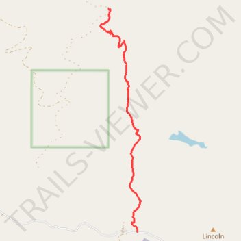
Meadow Creek Trail
- Distance: 6.1 Km
- Elevation gain: 288 m
- Maximum elevation: 2,385 m
- Elevation loss: 34 m
- Minimum elevation: 2,129 m
- Moving time: 2 h 4 m
- Moving speed: 2.9 Km/h
- Maximum speed: 5.8 Km/h
- Total time: 2 h 4 m
- Global speed: 2.9 Km/h
Interactive trail map
Thank you for supporting this site ❤️
Make a donation
Make a donation
Gear up for your next adventure:
As an Amazon Associate, this site earns from qualifying purchases at no extra cost to you.
Trail profile
- Distance: 6.1 Km
- Elevation gain: 288 m
- Maximum elevation: 2,385 m
- Elevation loss: 34 m
- Minimum elevation: 2,129 m
- Moving time: 2 h 4 m
- Moving speed: 2.9 Km/h
- Maximum speed: 5.8 Km/h
- Total time: 2 h 4 m
- Global speed: 2.9 Km/h
Thank you for supporting this site ❤️
Make a donation
Make a donation
Gear up for your next adventure:
As an Amazon Associate, this site earns from qualifying purchases at no extra cost to you.
About this trail
Name: Meadow Creek Trail trail, distance, elevation, map, profile, GPS track
Start: 4785, Taylor Fork Road, Gallatin County, Montana, 59730, United States (45.07078 -111.30355)
End: Dead Horse Trail, Gallatin County, Montana, United States (45.11240 -111.31119)
Coordinates: 45.07078 -111.31325 45.11240 -111.30270
Thank you for supporting this site ❤️
Make a donation
Make a donation
Gear up for your next adventure:
As an Amazon Associate, this site earns from qualifying purchases at no extra cost to you.