Import a GPX file

Derrynane National Park

#Hiking #Loop

  • Distance: 9.0 Km
  • Elevation gain: 220 m
  • Maximum elevation: 132 m
  • Elevation loss: 219 m
  • Minimum elevation: 0 m

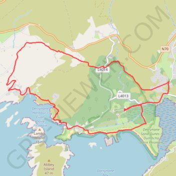
Interactive trail map

Trail profile

  • Distance: 9.0 Km
  • Elevation gain: 220 m
  • Maximum elevation: 132 m
  • Elevation loss: 219 m
  • Minimum elevation: 0 m

About this trail

Other hiking, mountain biking, running and outdoor activity trails

Click on a trail to view its statistics, map and profile.

Waterville - Derrynane Beach - Caherdaniel

Ireland > County Kerry

#Hiking

Distance: 16.2 Km • Elevation gain: 439 m • Maximum elevation: 243 m

Gear up for your next adventure:

📱Shockproof Phone Cases - Extra protection for your smartphone against drops on rocky terrain
🎒40L Day Hiking Backpacks - Comfortable packs with hydration support for long days exploring topographic peaks
🌬️Windbreaker Jackets - Wind protection jackets
📷Backpack Camera Clips - Quick access to your camera while keeping your hands free for climbing
🧼Biodegradable Outdoor Soap - Clean gear and yourself without harming the local ecosystem

As an Amazon Associate, this site earns from qualifying purchases at no extra cost to you.