Import a GPX file

Painshill Loop

Loop hike from Cobham via River Mole, The Lake, Woollett Bidge, Grotto Island, Crystal Grotto and Five Arch Bridge. #Hiking #Loop #Nature #River #Lake #Forest #Cave

  • Distance: 3.7 Km
  • Elevation gain: 29 m
  • Maximum elevation: 33 m
  • Elevation loss: 29 m
  • Minimum elevation: 15 m

Interactive trail map

Trail profile

  • Distance: 3.7 Km
  • Elevation gain: 29 m
  • Maximum elevation: 33 m
  • Elevation loss: 29 m
  • Minimum elevation: 15 m

About this trail
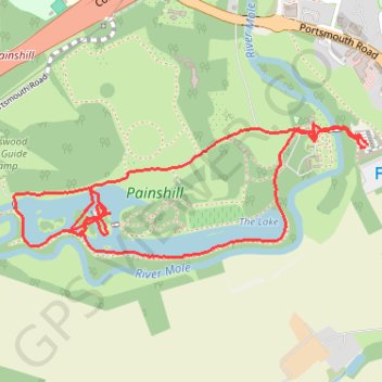
Name: Painshill Loop trail, distance, elevation, map, profile, GPS track

Start: Cobham, Elmbridge, Surrey, England, KT11 1AG, United Kingdom (51.33002 -0.41917)

End: Cobham, Elmbridge, Surrey, England, KT11 1AG, United Kingdom (51.33007 -0.41906)

Coordinates: 51.32711 -0.43395 51.33062 -0.41906

Gear up for your next adventure:

🕯️Emergency Whistles - Safety whistles for hiking
📱Tablet Tripod Mounts - Steady platforms for viewing digital maps or taking long exposures
🥾Heavy Duty Hiking Boots - Ankle-supporting boots for carrying heavy packs on steep contours
🛌Sleeping Bags - Sleeping bags for outdoor camping
🦯Adjustable Trekking Poles - Reduce impact on knees when descending steep topographic ridges

As an Amazon Associate, this site earns from qualifying purchases at no extra cost to you.