Make a donation
Gear up for your next adventure:
As an Amazon Associate, this site earns from qualifying purchases at no extra cost to you.
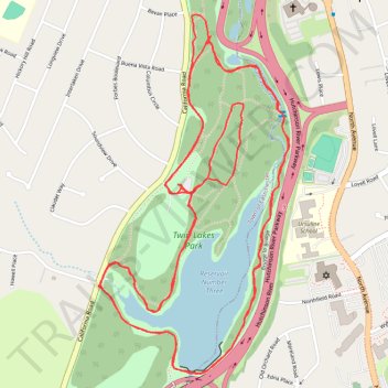
Eastchester, walk around lake in Twin Lakes Park
- Distance: 7.3 Km
- Elevation gain: 47 m
- Maximum elevation: 53 m
- Elevation loss: 46 m
- Minimum elevation: 38 m
- Moving time: 1 h 21 m
- Moving speed: 5.4 Km/h
- Maximum speed: 11.8 Km/h
- Total time: 1 h 21 m
- Global speed: 5.4 Km/h
Interactive trail map
Make a donation
Gear up for your next adventure:
As an Amazon Associate, this site earns from qualifying purchases at no extra cost to you.
Trail profile
- Distance: 7.3 Km
- Elevation gain: 47 m
- Maximum elevation: 53 m
- Elevation loss: 46 m
- Minimum elevation: 38 m
- Moving time: 1 h 21 m
- Moving speed: 5.4 Km/h
- Maximum speed: 11.8 Km/h
- Total time: 1 h 21 m
- Global speed: 5.4 Km/h
Make a donation
Gear up for your next adventure:
As an Amazon Associate, this site earns from qualifying purchases at no extra cost to you.
About this trail
Name: Eastchester, walk around lake in Twin Lakes Park trail, distance, elevation, map, profile, GPS track
Coordinates: 40.94423 -73.80516 40.95408 -73.79823
Make a donation
Gear up for your next adventure:
As an Amazon Associate, this site earns from qualifying purchases at no extra cost to you.
Other hiking, mountain biking, running and outdoor activity trails
Click on a trail to view its statistics, map and profile.
Twin Lakes Park trails
United States > New York > Westchester County > Town of Eastchester
Distance: 10.0 Km • Elevation gain: 79 m • Maximum elevation: 54 m
Bronx River Pathway
United States > New York > Westchester County > City of Yonkers
Distance: 22.2 Km • Elevation gain: 154 m • Maximum elevation: 56 m