Make a donation
Gear up for your next adventure:
As an Amazon Associate, this site earns from qualifying purchases at no extra cost to you.
Trail Canyon Falls in Angeles National Forest
The hike to Trail Canyon Falls in the Angeles National Forest offers a moderately challenging journey through diverse landscapes. As you traverse the trail, you'll encounter a babbling creek, verdant forests, rugged canyon walls, and enjoy views of the San Gabriel Mountains. The trail culminates at the picturesque 30-foot Trail Canyon Falls, where water cascades down a rocky face into a serene pool below. #Hiking #Waterfall #Canyon #Mountain #Forest #Nature
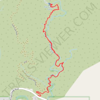
- Distance: 7.6 Km
- Elevation gain: 366 m
- Maximum elevation: 757 m
- Elevation loss: 367 m
- Minimum elevation: 539 m
- Moving time: 2 h 15 m
- Moving speed: 3.4 Km/h
- Maximum speed: 7.1 Km/h
- Total time: 2 h 36 m
- Global speed: 2.9 Km/h
Interactive trail map
Make a donation
Gear up for your next adventure:
As an Amazon Associate, this site earns from qualifying purchases at no extra cost to you.
Trail profile
- Distance: 7.6 Km
- Elevation gain: 366 m
- Maximum elevation: 757 m
- Elevation loss: 367 m
- Minimum elevation: 539 m
- Moving time: 2 h 15 m
- Moving speed: 3.4 Km/h
- Maximum speed: 7.1 Km/h
- Total time: 2 h 36 m
- Global speed: 2.9 Km/h
Make a donation
Gear up for your next adventure:
As an Amazon Associate, this site earns from qualifying purchases at no extra cost to you.
About this trail
Name: Trail Canyon Falls in Angeles National Forest trail, distance, elevation, map, profile, GPS track
Start: North Trail Canyon Road, Los Angeles County, California, United States (34.30376 -118.25797)
End: Big Tujunga Canyon Road, Los Angeles County, California, United States (34.30379 -118.25813)
Coordinates: 34.30359 -118.25840 34.32048 -118.25239
Make a donation
Gear up for your next adventure:
As an Amazon Associate, this site earns from qualifying purchases at no extra cost to you.
Other hiking, mountain biking, running and outdoor activity trails
Click on a trail to view its statistics, map and profile.
Trail Canyon Trail to Trail Canyon Falls
United States > California > Los Angeles County
Distance: 3.1 Km • Elevation gain: 266 m • Maximum elevation: 755 m