Make a donation
Gear up for your next adventure:
As an Amazon Associate, this site earns from qualifying purchases at no extra cost to you.
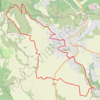
Cycling from tefahot to hazon and back through maghar
- Distance: 15.7 Km
- Elevation gain: 404 m
- Maximum elevation: 387 m
- Elevation loss: 405 m
- Minimum elevation: 87 m
- Moving time: 1 h 45 m
- Moving speed: 8.9 Km/h
- Maximum speed: 44.4 Km/h
- Total time: 2 h 52 m
- Global speed: 5.5 Km/h
Interactive trail map
Make a donation
Gear up for your next adventure:
As an Amazon Associate, this site earns from qualifying purchases at no extra cost to you.
Trail profile
- Distance: 15.7 Km
- Elevation gain: 404 m
- Maximum elevation: 387 m
- Elevation loss: 405 m
- Minimum elevation: 87 m
- Moving time: 1 h 45 m
- Moving speed: 8.9 Km/h
- Maximum speed: 44.4 Km/h
- Total time: 2 h 52 m
- Global speed: 5.5 Km/h
Make a donation
Gear up for your next adventure:
As an Amazon Associate, this site earns from qualifying purchases at no extra cost to you.
About this trail
Name: Cycling from tefahot to hazon and back through maghar trail, distance, elevation, map, profile, GPS track
Coordinates: 32.86763 35.37882 32.90341 35.41933
Make a donation
Gear up for your next adventure:
As an Amazon Associate, this site earns from qualifying purchases at no extra cost to you.
Other hiking, mountain biking, running and outdoor activity trails
Click on a trail to view its statistics, map and profile.
Cycling from Tefahot to Migdal and back
Israel > North District > Merom HaGalil Regional Council > Tefahot
Distance: 35.5 Km • Elevation gain: 551 m • Maximum elevation: 120 m
Cycling from Tefahot to the Kineret
Israel > North District > Merom HaGalil Regional Council > Tefahot
Distance: 18.9 Km • Elevation gain: 315 m • Maximum elevation: 126 m
Cycling from the Kineret to Tefahot
Israel > North District > Emek HaYarden Regional Council
Distance: 21.0 Km • Elevation gain: 479 m • Maximum elevation: 119 m
MTB cycling from Tefahot to Masad
Israel > North District > Merom HaGalil Regional Council > Tefahot
Distance: 16.6 Km • Elevation gain: 429 m • Maximum elevation: 298 m
Make a donation
Gear up for your next adventure:
As an Amazon Associate, this site earns from qualifying purchases at no extra cost to you.
Cycling from Tefahot to Eilabun
Israel > North District > Merom HaGalil Regional Council > Tefahot
Distance: 11.5 Km • Elevation gain: 249 m • Maximum elevation: 128 m
Cycling from Tefahot to Eilabun
Israel > North District > Merom HaGalil Regional Council > Tefahot
Distance: 12.1 Km • Elevation gain: 278 m • Maximum elevation: 158 m
MTB cycling track near Maghar
Israel > North District > Merom HaGalil Regional Council > Tefahot
Distance: 9.0 Km • Elevation gain: 122 m • Maximum elevation: 115 m