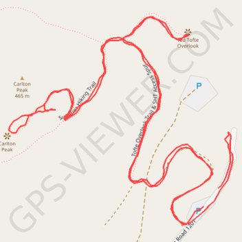
USA, MN, Carlton Peak and Tofte Peak, Temperance River State Park
Cook County Hiking
- Distance: 2.6 Km
- Elevation gain: 123 m
- Maximum elevation: 448 m
- Elevation loss: 125 m
- Minimum elevation: 343 m
- Moving time: 43 m 43 s
- Moving speed: 3.5 Km/h
- Maximum speed: 5.5 Km/h
- Total time: 53 m 48 s
- Global speed: 2.9 Km/h
Interactive trail map
Trail profile
- Distance: 2.6 Km
- Elevation gain: 123 m
- Maximum elevation: 448 m
- Elevation loss: 125 m
- Minimum elevation: 343 m
- Moving time: 43 m 43 s
- Moving speed: 3.5 Km/h
- Maximum speed: 5.5 Km/h
- Total time: 53 m 48 s
- Global speed: 2.9 Km/h
About this trail
Name: USA, MN, Carlton Peak and Tofte Peak, Temperance River State Park trail, distance, elevation, map, profile, GPS track
Start: Forest Road 1201, Tofte Township, Cook County, Minnesota, 55613, United States (47.58267 -90.85561)
End: Forest Road 1201, Tofte Township, Cook County, Minnesota, 55613, United States (47.58240 -90.85592)
Coordinates: 47.58214 -90.86008 47.58514 -90.85530
Other hiking, mountain biking, running and outdoor activity trails
Click on a trail to view its statistics, map and profile.
USA MN SHT - South Cross River Campsite to Britton Peak Trailhead
United States > Minnesota > Cook County > Schroeder Township
Distance: 12.5 Km • Elevation gain: 391 m • Maximum elevation: 439 m