Make a donation
Gear up for your next adventure:
As an Amazon Associate, this site earns from qualifying purchases at no extra cost to you.
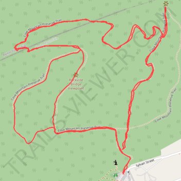
Cove Mountain Preserve Trail
- Distance: 7.7 Km
- Elevation gain: 359 m
- Maximum elevation: 340 m
- Elevation loss: 359 m
- Minimum elevation: 175 m
- Moving time: 2 h 2 m
- Moving speed: 3.8 Km/h
- Maximum speed: 8.3 Km/h
- Total time: 2 h 6 m
- Global speed: 3.6 Km/h
Interactive trail map
Make a donation
Gear up for your next adventure:
As an Amazon Associate, this site earns from qualifying purchases at no extra cost to you.
Trail profile
- Distance: 7.7 Km
- Elevation gain: 359 m
- Maximum elevation: 340 m
- Elevation loss: 359 m
- Minimum elevation: 175 m
- Moving time: 2 h 2 m
- Moving speed: 3.8 Km/h
- Maximum speed: 8.3 Km/h
- Total time: 2 h 6 m
- Global speed: 3.6 Km/h
Make a donation
Gear up for your next adventure:
As an Amazon Associate, this site earns from qualifying purchases at no extra cost to you.
About this trail
Name: Cove Mountain Preserve Trail trail, distance, elevation, map, profile, GPS track
Start: Sylvan Street, Marysville, Perry County, Pennsylvania, 17053, United States (40.34706 -76.93835)
End: Sylvan Street, Marysville, Perry County, Pennsylvania, 17053, United States (40.34708 -76.93838)
Coordinates: 40.34706 -76.94503 40.35485 -76.93570
Make a donation
Gear up for your next adventure:
As an Amazon Associate, this site earns from qualifying purchases at no extra cost to you.
Other hiking, mountain biking, running and outdoor activity trails
Click on a trail to view its statistics, map and profile.
Cove Mountain Preserve
United States > Pennsylvania > Perry County > Marysville
Distance: 5.5 Km • Elevation gain: 213 m • Maximum elevation: 340 m
Cove Mountain Preserve trails
United States > Pennsylvania > Perry County > Marysville
Distance: 9.6 Km • Elevation gain: 390 m • Maximum elevation: 372 m