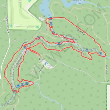
Bluff Trail and Canyon Trail Loop in Matthiessen State Park
The Bluff Trail and Canyon Trail Loop offers a captivating hiking experience through diverse landscapes. Hikers will encounter impressive rock formations, lush vegetation, and seasonal waterfalls that enhance the park's natural beauty. The trail features scenic overlooks with breathtaking views of the Vermilion River and deep canyons, making it a delightful choice for nature enthusiasts looking for a moderately challenging adventure. #Hiking #Loop #Canyon #Waterfall #Forest #Nature #River
- Distance: 3.8 Km
- Elevation gain: 63 m
- Maximum elevation: 193 m
- Elevation loss: 67 m
- Minimum elevation: 163 m
- Moving time: 1 h 2 m
- Moving speed: 3.6 Km/h
- Maximum speed: 7.0 Km/h
- Total time: 1 h 8 m
- Global speed: 3.3 Km/h
Interactive trail map
Trail profile
- Distance: 3.8 Km
- Elevation gain: 63 m
- Maximum elevation: 193 m
- Elevation loss: 67 m
- Minimum elevation: 163 m
- Moving time: 1 h 2 m
- Moving speed: 3.6 Km/h
- Maximum speed: 7.0 Km/h
- Total time: 1 h 8 m
- Global speed: 3.3 Km/h
About this trail
Name: Bluff Trail and Canyon Trail Loop in Matthiessen State Park trail, distance, elevation, map, profile, GPS track
Start: CLOSED, Deer Park, LaSalle County, Illinois, 61348, United States (41.29636 -89.02603)
End: Fort, Bluff Trail, Deer Park, LaSalle County, Illinois, 61348, United States (41.29659 -89.02637)
Coordinates: 41.29380 -89.02946 41.29915 -89.01979