Make a donation
Gear up for your next adventure:
As an Amazon Associate, this site earns from qualifying purchases at no extra cost to you.
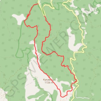
Đorov most - Kadijevac - Kukavica - Kozije stene - Đorov mos...
- Distance: 17.3 Km
- Elevation gain: 1,015 m
- Maximum elevation: 1,710 m
- Elevation loss: 1,073 m
- Minimum elevation: 699 m
Interactive trail map
Make a donation
Gear up for your next adventure:
As an Amazon Associate, this site earns from qualifying purchases at no extra cost to you.
Trail profile
- Distance: 17.3 Km
- Elevation gain: 1,015 m
- Maximum elevation: 1,710 m
- Elevation loss: 1,073 m
- Minimum elevation: 699 m
Make a donation
Gear up for your next adventure:
As an Amazon Associate, this site earns from qualifying purchases at no extra cost to you.
About this trail
Name: Đorov most - Kadijevac - Kukavica - Kozije stene - Đorov mos... trail, distance, elevation, map, profile, GPS track
Coordinates: 43.31902 20.72620 43.36612 20.76268
Make a donation
Gear up for your next adventure:
As an Amazon Associate, this site earns from qualifying purchases at no extra cost to you.
Other hiking, mountain biking, running and outdoor activity trails
Click on a trail to view its statistics, map and profile.
Kopaonik - vrh Kukavica kanjonom Samokovske reke
Serbia > Central Serbia > Raska Administrative District > Raska Municipality > Josanicka Banja > Palješnica
Distance: 17.8 Km • Elevation gain: 1,077 m • Maximum elevation: 1,710 m
2022_Yu
Slovenia > Ajdovščina > Žapuže
Distance: 2,457.3 Km • Elevation gain: 32,048 m • Maximum elevation: 1,950 m
Đorov most,Kadijevac,Kukavica,Kozje stene,Mijatovića jaz,Đor...
Serbia > Central Serbia > Raska Administrative District > Raska Municipality > Josanicka Banja > Palješnica
Distance: 18.2 Km • Elevation gain: 1,117 m • Maximum elevation: 1,709 m
Kopaonik: od Đorovog mosta, Samokovska reka, Kadijevac, vrh ...
Serbia > Central Serbia > Raska Administrative District > Raska Municipality > Josanicka Banja
Distance: 18.1 Km • Elevation gain: 1,119 m • Maximum elevation: 1,711 m
Make a donation
Gear up for your next adventure:
As an Amazon Associate, this site earns from qualifying purchases at no extra cost to you.