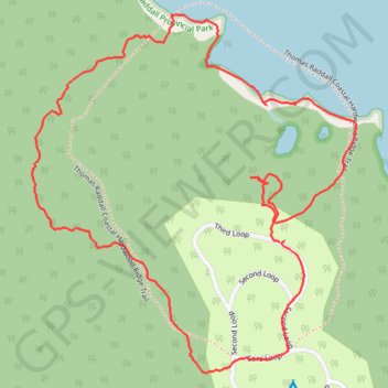
Coastal Hardwood Ridge Loop
#Hiking #Backcountry #Beach #Forest
- Distance: 3.0 Km
- Elevation gain: 32 m
- Maximum elevation: 25 m
- Elevation loss: 32 m
- Minimum elevation: 0 m
- Moving time: 59 m 32 s
- Moving speed: 3.0 Km/h
- Maximum speed: 5.6 Km/h
- Total time: 1 h 1 m
- Global speed: 3.0 Km/h
Interactive trail map
Trail profile
- Distance: 3.0 Km
- Elevation gain: 32 m
- Maximum elevation: 25 m
- Elevation loss: 32 m
- Minimum elevation: 0 m
- Moving time: 59 m 32 s
- Moving speed: 3.0 Km/h
- Maximum speed: 5.6 Km/h
- Total time: 1 h 1 m
- Global speed: 3.0 Km/h
About this trail
Name: Coastal Hardwood Ridge Loop trail, distance, elevation, map, profile, GPS track
Coordinates: 43.84373 -64.89203 43.85057 -64.88347
Other hiking, mountain biking, running and outdoor activity trails
Click on a trail to view its statistics, map and profile.
Thomas Raddall Loop
Canada > Nova Scotia > Queens County > Port Joli
Hiking
Distance: 10.9 Km • Elevation gain: 102 m • Maximum elevation: 44 m