Import a GPX file

Geocaching in Forest reserve

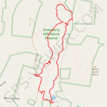
Strawberry Hill Nature Reserve

  • Distance: 5.0 Km
  • Elevation gain: 121 m
  • Maximum elevation: 343 m
  • Elevation loss: 122 m
  • Minimum elevation: 273 m
  • Moving time: 1 h 33 m
  • Moving speed: 3.2 Km/h
  • Maximum speed: 7.7 Km/h
  • Total time: 2 h 12 m
  • Global speed: 2.2 Km/h

Interactive trail map

Trail profile

  • Distance: 5.0 Km
  • Elevation gain: 121 m
  • Maximum elevation: 343 m
  • Elevation loss: 122 m
  • Minimum elevation: 273 m
  • Moving time: 1 h 33 m
  • Moving speed: 3.2 Km/h
  • Maximum speed: 7.7 Km/h
  • Total time: 2 h 12 m
  • Global speed: 2.2 Km/h

About this trail

Name: Geocaching in Forest reserve trail, distance, elevation, map, profile, GPS track

Start: Swamp Creek Trail, Hamiltonban Township, Adams County, Pennsylvania, United States (39.80334 -77.41489)

End: Swamp Creek Trail, Hamiltonban Township, Adams County, Pennsylvania, United States (39.80353 -77.41496)

Coordinates: 39.80328 -77.41817 39.81733 -77.41111

Gear up for your next adventure:

📷Backpack Camera Clips - Quick access to your camera while keeping your hands free for climbing
🏫Topographic World Globes - 3D physical relief globes to understand global geography
🧴Sunscreen SPF - Sun protection for outdoor activities
🎒Dry Bags - Waterproof bags for outdoor gear
🦘Outback Survival Gear - Essential gear for Australian outback

As an Amazon Associate, this site earns from qualifying purchases at no extra cost to you.