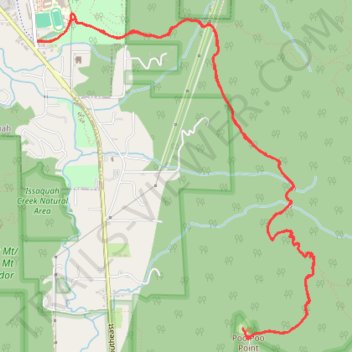
Poo-Poo Point Trail
Starting near the Issaquah High School side of West Tiger Mountain, the trail enters a shaded forest and climbs steadily through the lower slopes of the natural resources conservation area.
It then follows the wooded Poo Poo Point route, passing small creek draws and mossy woodland before reaching the open launch area.
At Poo Poo Point, the hike opens onto views over the Issaquah lowlands, with paragliders often using the grassy clearing above the forested hills.
#Hiking #Mountain #Forest #Overlook
- Distance: 11.2 Km
- Elevation gain: 653 m
- Maximum elevation: 563 m
- Elevation loss: 653 m
- Minimum elevation: 38 m
- Moving time: 2 h 37 m
- Moving speed: 4.3 Km/h
- Maximum speed: 15.4 Km/h
- Total time: 3 h 1 m
- Global speed: 3.7 Km/h
Interactive trail map
Trail profile
- Distance: 11.2 Km
- Elevation gain: 653 m
- Maximum elevation: 563 m
- Elevation loss: 653 m
- Minimum elevation: 38 m
- Moving time: 2 h 37 m
- Moving speed: 4.3 Km/h
- Maximum speed: 15.4 Km/h
- Total time: 3 h 1 m
- Global speed: 3.7 Km/h
About this trail
Name: Poo-Poo Point Trail trail, distance, elevation, map, profile, GPS track
Coordinates: 47.49873 -122.02970 47.52127 -122.00128
Other hiking, mountain biking, running and outdoor activity trails
Click on a trail to view its statistics, map and profile.
Poo-Poo Point via Chirico Trail in West Tiger Mountain Natural Resource Conservation Area
United States > Washington > King County
Hiking the Chirico Trail to Poo-Poo Point offers a delightful escape into nature, where the lush conifer forests gradually yield to breathtaking views. As you ascend, the trail's charm is accentuated by the steep stone steps, leading you through a landscape reminiscent of a classical painting, and culminating…
Distance: 6.5 Km • Elevation gain: 499 m • Maximum elevation: 546 m
Poo-Poo Point Trail in West Tiger Mountain Natural Resources Conservation Area
United States > Washington > King County > Issaquah
The Poo-Poo Point Trail in the West Tiger Mountain Natural Resources Conservation Area offers hikers a journey through lush, moss-covered forests, crossing picturesque streams via well-maintained bridges. Upon reaching Poo-Poo Point, you're rewarded with expansive views of the surrounding valleys, with the…
Distance: 11.0 Km • Elevation gain: 618 m • Maximum elevation: 563 m
Northern part of the Pacific Crest Trail (PCT)
United States > Oregon > Klamath County
Hike on the Pacific Crest National Scenic Trail from Crater Lake to Canada Border through Oregon and Washington along the Sierra Nevada and Cascade mountain ranges. #Hiking #Mountain #SierraNevada #Cascade #Nature #Forest #Park #PCT
Distance: 1,198.3 Km • Elevation gain: 44,308 m • Maximum elevation: 2,307 m
Poo Poo Point via High School Trail and Poo Poo Point Trail
United States > Washington > King County > Issaquah
Distance: 11.4 Km • Elevation gain: 635 m • Maximum elevation: 563 m
Poo Poo Point - Rescue Loop
United States > Washington > King County
Distance: 7.8 Km • Elevation gain: 655 m • Maximum elevation: 555 m
Poo Poo Point Rescue Trail
United States > Washington > King County
Distance: 7.1 Km • Elevation gain: 567 m • Maximum elevation: 556 m
Talus Rocks
United States > Washington > King County > Issaquah
Hiking Trails
Distance: 9.9 Km • Elevation gain: 493 m • Maximum elevation: 407 m