Thank you for supporting this site ❤️
Make a donation
Make a donation
Gear up for your next adventure:
As an Amazon Associate, this site earns from qualifying purchases at no extra cost to you.
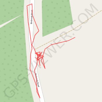
RE TF280880
- Distance: 0.4 Km
- Elevation gain: 9 m
- Maximum elevation: 89 m
- Elevation loss: 6 m
- Minimum elevation: 82 m
- Moving time: 12 m 32 s
- Moving speed: 1.8 Km/h
- Maximum speed: 4.0 Km/h
- Total time: 35 m 58 s
- Global speed: 0.6 Km/h
Interactive trail map
Thank you for supporting this site ❤️
Make a donation
Make a donation
Gear up for your next adventure:
As an Amazon Associate, this site earns from qualifying purchases at no extra cost to you.
Trail profile
- Distance: 0.4 Km
- Elevation gain: 9 m
- Maximum elevation: 89 m
- Elevation loss: 6 m
- Minimum elevation: 82 m
- Moving time: 12 m 32 s
- Moving speed: 1.8 Km/h
- Maximum speed: 4.0 Km/h
- Total time: 35 m 58 s
- Global speed: 0.6 Km/h
Thank you for supporting this site ❤️
Make a donation
Make a donation
Gear up for your next adventure:
As an Amazon Associate, this site earns from qualifying purchases at no extra cost to you.
About this trail
Name: RE TF280880 trail, distance, elevation, map, profile, GPS track
Coordinates: 53.37346 -0.07555 53.37436 -0.07478
Thank you for supporting this site ❤️
Make a donation
Make a donation
Gear up for your next adventure:
As an Amazon Associate, this site earns from qualifying purchases at no extra cost to you.