Thank you for supporting this site ❤️
Make a donation
Make a donation
Gear up for your next adventure:
As an Amazon Associate, this site earns from qualifying purchases at no extra cost to you.
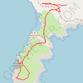
Neist Point Walk
- Distance: 3.6 Km
- Elevation gain: 150 m
- Maximum elevation: 94 m
- Elevation loss: 147 m
- Minimum elevation: 4 m
- Moving time: 59 m 47 s
- Moving speed: 3.6 Km/h
- Maximum speed: 17.6 Km/h
- Total time: 1 h 32 m
- Global speed: 2.3 Km/h
Interactive trail map
Thank you for supporting this site ❤️
Make a donation
Make a donation
Gear up for your next adventure:
As an Amazon Associate, this site earns from qualifying purchases at no extra cost to you.
Trail profile
- Distance: 3.6 Km
- Elevation gain: 150 m
- Maximum elevation: 94 m
- Elevation loss: 147 m
- Minimum elevation: 4 m
- Moving time: 59 m 47 s
- Moving speed: 3.6 Km/h
- Maximum speed: 17.6 Km/h
- Total time: 1 h 32 m
- Global speed: 2.3 Km/h
Thank you for supporting this site ❤️
Make a donation
Make a donation
Gear up for your next adventure:
As an Amazon Associate, this site earns from qualifying purchases at no extra cost to you.
About this trail
Name: Neist Point Walk trail, distance, elevation, map, profile, GPS track
Coordinates: 57.42113 -6.78866 57.43015 -6.77757
Thank you for supporting this site ❤️
Make a donation
Make a donation
Gear up for your next adventure:
As an Amazon Associate, this site earns from qualifying purchases at no extra cost to you.