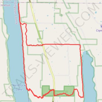
Import a GPX file

Hemlock DH

  • Distance: 20.7 Km
  • Elevation gain: 670 m
  • Maximum elevation: 540 m
  • Elevation loss: 672 m
  • Minimum elevation: 264 m

Interactive trail map

Trail profile

  • Distance: 20.7 Km
  • Elevation gain: 670 m
  • Maximum elevation: 540 m
  • Elevation loss: 672 m
  • Minimum elevation: 264 m

About this trail

Name: Hemlock DH trail, distance, elevation, map, profile, GPS track

Start: East Lake Road, Town of Canadice, Ontario County, New York, 14466, United States (42.75756 -77.61071)

End: Town of Canadice, Ontario County, New York, 14466, United States (42.76257 -77.61101)

Coordinates: 42.72023 -77.61126 42.76257 -77.57162

Gear up for your next adventure:

🌬️Windbreaker Jackets - Wind protection jackets
📣High-Decibel Survival Whistles - Signaling tool for rescue that carries much further than a human voice
🩹Blister Prevention Tape - Apply to friction points before they become painful sores
🪫Rechargeable Headlamps - USB rechargeable headlamps
🧥Down Jackets - Insulated jackets for cold weather

As an Amazon Associate, this site earns from qualifying purchases at no extra cost to you.