Make a donation
Gear up for your next adventure:
As an Amazon Associate, this site earns from qualifying purchases at no extra cost to you.
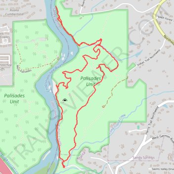
East Palisades and Bamboo Forest Loop
Starting from the Whitewater Creek side of the East Palisades unit, this loop follows the wooded bank of the Chattahoochee River upstream, passing rocky river edges, small islands, and open views across the water.
At the northern end of the route, the path reaches the Bamboo Forest, a distinctive riverside grove, then turns back along the Chattahoochee River corridor before beginning a broader return loop.
The final section winds through the quieter interior of the Palisades Unit, crossing shaded forest paths, rolling ridges, ravines, and hillside bends before descending back toward Whitewater Creek and the riverfront.
#Hiking #Loop #Forest #River #Nature
- Distance: 7.0 Km
- Elevation gain: 203 m
- Maximum elevation: 310 m
- Elevation loss: 203 m
- Minimum elevation: 233 m
- Moving time: 1 h 56 m
- Moving speed: 3.6 Km/h
- Maximum speed: 6.3 Km/h
- Total time: 2 h 20 m
- Global speed: 3.0 Km/h
Interactive trail map
Make a donation
Gear up for your next adventure:
As an Amazon Associate, this site earns from qualifying purchases at no extra cost to you.
Trail profile
- Distance: 7.0 Km
- Elevation gain: 203 m
- Maximum elevation: 310 m
- Elevation loss: 203 m
- Minimum elevation: 233 m
- Moving time: 1 h 56 m
- Moving speed: 3.6 Km/h
- Maximum speed: 6.3 Km/h
- Total time: 2 h 20 m
- Global speed: 3.0 Km/h
Make a donation
Gear up for your next adventure:
As an Amazon Associate, this site earns from qualifying purchases at no extra cost to you.
About this trail
Name: East Palisades and Bamboo Forest Loop trail, distance, elevation, map, profile, GPS track
Start: East Palisades, Atlanta, Fulton County, Georgia, 30339, United States (33.87776 -84.44192)
End: East Palisades, Atlanta, Fulton County, Georgia, 30339, United States (33.87784 -84.44191)
Coordinates: 33.87776 -84.44311 33.89508 -84.43497
Make a donation
Gear up for your next adventure:
As an Amazon Associate, this site earns from qualifying purchases at no extra cost to you.
Other hiking, mountain biking, running and outdoor activity trails
Click on a trail to view its statistics, map and profile.
Bamboo Forest via East Palisades Loop in Chattahoochee River National Recreation Area
United States > Georgia > Fulton County > Atlanta
The Bamboo Forest via East Palisades Loop offers a unique hiking experience that brings you close to nature while being conveniently located near Atlanta. Hikers can enjoy views of the Chattahoochee River, traverse through a small but enchanting bamboo forest, and explore sections with striking rock…
Distance: 6.6 Km • Elevation gain: 188 m • Maximum elevation: 310 m
East Palisades and Bamboo Forest Loop Trail
United States > Georgia > Fulton County > Atlanta
The East Palisades and Bamboo Forest Loop Trail in the Chattahoochee River National Recreation Area offers hikers a scenic journey through diverse landscapes. As you traverse the trail, you'll encounter the towering bamboo forest—a unique and unexpected feature in Georgia—that creates a serene atmosphere…
Distance: 7.0 Km • Elevation gain: 205 m • Maximum elevation: 310 m
Atlanta, Lilburn, Yellow River Park, Panola, Jonesboro
United States > Georgia > Fayette County > Peachtree City > Stop
Distance: 335.0 Km • Elevation gain: 4,058 m • Maximum elevation: 338 m