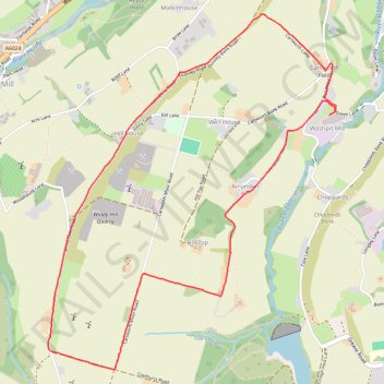
Cartworth Moor Loop
- Distance: 5.6 Km
- Elevation gain: 157 m
- Maximum elevation: 346 m
- Elevation loss: 157 m
- Minimum elevation: 217 m
- Moving time: 1 h 59 m
- Moving speed: 2.8 Km/h
- Maximum speed: 4.4 Km/h
- Total time: 2 h 26 m
- Global speed: 2.3 Km/h
Interactive trail map
Trail profile
- Distance: 5.6 Km
- Elevation gain: 157 m
- Maximum elevation: 346 m
- Elevation loss: 157 m
- Minimum elevation: 217 m
- Moving time: 1 h 59 m
- Moving speed: 2.8 Km/h
- Maximum speed: 4.4 Km/h
- Total time: 2 h 26 m
- Global speed: 2.3 Km/h
About this trail
Name: Cartworth Moor Loop trail, distance, elevation, map, profile, GPS track
Coordinates: 53.54589 -1.80818 53.56216 -1.78600
Other hiking, mountain biking, running and outdoor activity trails
Click on a trail to view its statistics, map and profile.
Ribble and Holmfirth Cliff
United Kingdom > England > Kirklees > Holmfirth > Washpit Mill
Distance: 5.9 Km • Elevation gain: 142 m • Maximum elevation: 276 m
Netherthong to Holmebridge via Upperthong (HVCW)
United Kingdom > England > Kirklees > Netherthong > Deanhouse
Netherthong - Deanhouse - Upperthong - Hogley Green - Booth House - Carr Green - Hinchliffe Mill - Holmbridge - Flush House - Austonley - Digley Reservoir - River Holme
Distance: 7.0 Km • Elevation gain: 192 m • Maximum elevation: 287 m
Washpit Mill via Holmfirth and Wooldale
United Kingdom > England > Kirklees > Holmfirth > Washpit Mill
Distance: 5.2 Km • Elevation gain: 127 m • Maximum elevation: 277 m
From Hade Edge
United Kingdom > England > Kirklees > Hade Edge > Harden
Hade Edge - Boshaw Whams Reservoir - Harden - Peak District National Park - Holme Styes Reservoir
Distance: 6.1 Km • Elevation gain: 166 m • Maximum elevation: 398 m
Cartworth Moor checkout
United Kingdom > England > Kirklees > Holmfirth > Washpit Mill
Distance: 4.3 Km • Elevation gain: 136 m • Maximum elevation: 327 m