Thank you for supporting this site ❤️
Make a donation
Make a donation
Gear up for your next adventure:
As an Amazon Associate, this site earns from qualifying purchases at no extra cost to you.
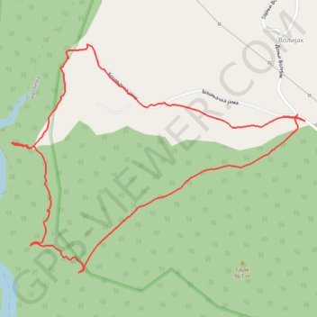
Uvac (Zlatiborska strana)
- Distance: 3.1 Km
- Elevation gain: 156 m
- Maximum elevation: 956 m
- Elevation loss: 156 m
- Minimum elevation: 840 m
- Moving time: 1 h 33 s
- Moving speed: 3.0 Km/h
- Maximum speed: 6.2 Km/h
- Total time: 1 h 45 m
- Global speed: 1.8 Km/h
Interactive trail map
Thank you for supporting this site ❤️
Make a donation
Make a donation
Gear up for your next adventure:
As an Amazon Associate, this site earns from qualifying purchases at no extra cost to you.
Trail profile
- Distance: 3.1 Km
- Elevation gain: 156 m
- Maximum elevation: 956 m
- Elevation loss: 156 m
- Minimum elevation: 840 m
- Moving time: 1 h 33 s
- Moving speed: 3.0 Km/h
- Maximum speed: 6.2 Km/h
- Total time: 1 h 45 m
- Global speed: 1.8 Km/h
Thank you for supporting this site ❤️
Make a donation
Make a donation
Gear up for your next adventure:
As an Amazon Associate, this site earns from qualifying purchases at no extra cost to you.
About this trail
Name: Uvac (Zlatiborska strana) trail, distance, elevation, map, profile, GPS track
Coordinates: 43.52474 19.77991 43.53108 19.79112
Thank you for supporting this site ❤️
Make a donation
Make a donation
Gear up for your next adventure:
As an Amazon Associate, this site earns from qualifying purchases at no extra cost to you.
Other hiking, mountain biking, running and outdoor activity trails
Click on a trail to view its statistics, map and profile.
2022_Yu
Slovenia > Ajdovščina > Žapuže
Distance: 2,457.3 Km • Elevation gain: 32,048 m • Maximum elevation: 1,950 m