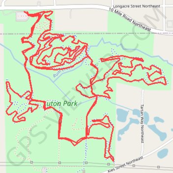
Import a GPX file

Luton Park MTB Loop

Mountain Bike loop in Luton Park. #MTB #Loop #Forest #Nature

  • Distance: 16.2 Km
  • Elevation gain: 167 m
  • Maximum elevation: 260 m
  • Elevation loss: 168 m
  • Minimum elevation: 239 m
  • Moving time: 1 h 15 m
  • Moving speed: 12.9 Km/h
  • Maximum speed: 33.4 Km/h
  • Total time: 1 h 19 m
  • Global speed: 12.3 Km/h

Interactive trail map

Trail profile

  • Distance: 16.2 Km
  • Elevation gain: 167 m
  • Maximum elevation: 260 m
  • Elevation loss: 168 m
  • Minimum elevation: 239 m
  • Moving time: 1 h 15 m
  • Moving speed: 12.9 Km/h
  • Maximum speed: 33.4 Km/h
  • Total time: 1 h 19 m
  • Global speed: 12.3 Km/h

About this trail

Name: Luton Park MTB Loop trail, distance, elevation, map, profile, GPS track

Start: Green Trail, Courtland Township, Kent County, Michigan, 49341, United States (43.11895 -85.52301)

End: Green Trail, Courtland Township, Kent County, Michigan, 49341, United States (43.11887 -85.52304)

Coordinates: 43.10907 -85.52490 43.11898 -85.51046

Gear up for your next adventure:

👣Snake & Scrub Gaiters - Protection against spinifex, mud, and snakes while walking off-track
🔋Solar Power Banks - Solar chargers for outdoors
🦟Insect Repellent - Protection against insects
🔥Ferrocerium Rod Fire Starters - Reliable fire lighting in wet or windy conditions without matches
🧭Military Style Lensatic Compass - Durable sighting compasses for advanced land navigation and surveying

As an Amazon Associate, this site earns from qualifying purchases at no extra cost to you.