Make a donation
Gear up for your next adventure:
As an Amazon Associate, this site earns from qualifying purchases at no extra cost to you.
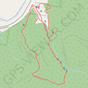
Birthday Mountain Loop Trail and Echidna Trail
Afternoon Hike in Denman common
- Distance: 4.9 Km
- Elevation gain: 198 m
- Maximum elevation: 305 m
- Elevation loss: 198 m
- Minimum elevation: 158 m
- Moving time: 1 h 11 m
- Moving speed: 4.1 Km/h
- Maximum speed: 7.1 Km/h
- Total time: 1 h 14 m
- Global speed: 4.0 Km/h
Interactive trail map
Make a donation
Gear up for your next adventure:
As an Amazon Associate, this site earns from qualifying purchases at no extra cost to you.
Trail profile
- Distance: 4.9 Km
- Elevation gain: 198 m
- Maximum elevation: 305 m
- Elevation loss: 198 m
- Minimum elevation: 158 m
- Moving time: 1 h 11 m
- Moving speed: 4.1 Km/h
- Maximum speed: 7.1 Km/h
- Total time: 1 h 14 m
- Global speed: 4.0 Km/h
Make a donation
Gear up for your next adventure:
As an Amazon Associate, this site earns from qualifying purchases at no extra cost to you.
About this trail
Name: Birthday Mountain Loop Trail and Echidna Trail trail, distance, elevation, map, profile, GPS track
Coordinates: -32.42343 150.33802 -32.41277 150.34502
Topography: New South Wales topographic map, elevation, terrain
Make a donation
Gear up for your next adventure:
As an Amazon Associate, this site earns from qualifying purchases at no extra cost to you.
Other hiking, mountain biking, running and outdoor activity trails
Click on a trail to view its statistics, map and profile.
Broadmeadow - Gulgong - Merrygoen - Dubbo railway
Australia > New South Wales > Newcastle
AU, NSW, railway
Distance: 374.4 Km • Elevation gain: 2,635 m • Maximum elevation: 504 m
Broadmeadow - Gulgong - Merrygoen - Dubbo railway
Australia > New South Wales > Newcastle
AU, NSW, railway
Distance: 375.3 Km • Elevation gain: 2,641 m • Maximum elevation: 517 m
Echidna Loop Trail
Australia > New South Wales > Stevens Flat
Distance: 2.2 Km • Elevation gain: 63 m • Maximum elevation: 183 m