Jemez MTB ride
Lunch Mountain Bike Ride
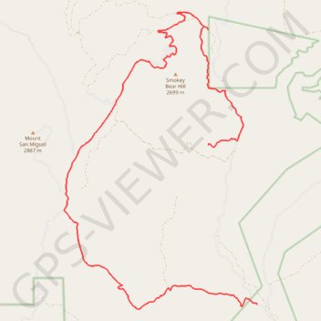
- Distance: 26.2 Km
- Elevation gain: 862 m
- Maximum elevation: 2,758 m
- Elevation loss: 691 m
- Minimum elevation: 2,223 m
- Moving time: 3 h 33 m
- Moving speed: 7.4 Km/h
- Maximum speed: 36.3 Km/h
- Total time: 4 h 17 m
- Global speed: 6.1 Km/h
Interactive trail map
Trail profile
- Distance: 26.2 Km
- Elevation gain: 862 m
- Maximum elevation: 2,758 m
- Elevation loss: 691 m
- Minimum elevation: 2,223 m
- Moving time: 3 h 33 m
- Moving speed: 7.4 Km/h
- Maximum speed: 36.3 Km/h
- Total time: 4 h 17 m
- Global speed: 6.1 Km/h
About this trail
Name: Jemez MTB ride trail, distance, elevation, map, profile, GPS track
Start: Forest Road 539, O'Neil Landing, Sandoval County, New Mexico, United States (35.81904 -106.79081)
End: O'Neil Landing, Sandoval County, New Mexico, United States (35.86226 -106.80736)
Coordinates: 35.81773 -106.85559 35.89833 -106.79081
Other hiking, mountain biking, running and outdoor activity trails
Click on a trail to view its statistics, map and profile.
Schoolhouse Mesa, Lake Fork Canyon and Rio Guadalupe Loop Ride from Gilman tunnels in Jemez National Recreation Area
United States > New Mexico > Sandoval County
Distance: 54.9 Km • Elevation gain: 901 m • Maximum elevation: 2,635 m
Potential route around GS camp in the Santa Fe National Forest
United States > New Mexico > Sandoval County
Distance: 2.1 Km • Elevation gain: 39 m • Maximum elevation: 2,471 m
Alternative road to climb to top of 376
United States > New Mexico > Sandoval County
Distance: 58.9 Km • Elevation gain: 969 m • Maximum elevation: 2,635 m