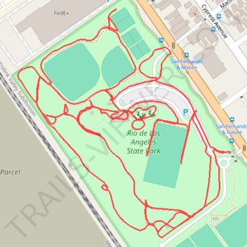
Rio de Los Angeles State Park
- Distance: 4.7 Km
- Elevation gain: 15 m
- Maximum elevation: 116 m
- Elevation loss: 15 m
- Minimum elevation: 108 m
- Moving time: 38 m 50 s
- Moving speed: 7.3 Km/h
- Maximum speed: 13.2 Km/h
- Total time: 38 m 50 s
- Global speed: 7.3 Km/h
Interactive trail map
Trail profile
- Distance: 4.7 Km
- Elevation gain: 15 m
- Maximum elevation: 116 m
- Elevation loss: 15 m
- Minimum elevation: 108 m
- Moving time: 38 m 50 s
- Moving speed: 7.3 Km/h
- Maximum speed: 13.2 Km/h
- Total time: 38 m 50 s
- Global speed: 7.3 Km/h
About this trail
Name: Rio de Los Angeles State Park trail, distance, elevation, map, profile, GPS track
Coordinates: 34.09684 -118.23890 34.10093 -118.23432