Make a donation
Gear up for your next adventure:
As an Amazon Associate, this site earns from qualifying purchases at no extra cost to you.
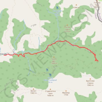
Stara planina: vodopadi Vurnje (Vurnja, Zuberski skok, Zuber...
- Distance: 20.2 Km
- Elevation gain: 933 m
- Maximum elevation: 1,379 m
- Elevation loss: 931 m
- Minimum elevation: 731 m
- Moving time: 6 h 47 s
- Moving speed: 3.4 Km/h
- Maximum speed: 6.3 Km/h
- Total time: 9 h 9 m
- Global speed: 2.2 Km/h
Interactive trail map
Make a donation
Gear up for your next adventure:
As an Amazon Associate, this site earns from qualifying purchases at no extra cost to you.
Trail profile
- Distance: 20.2 Km
- Elevation gain: 933 m
- Maximum elevation: 1,379 m
- Elevation loss: 931 m
- Minimum elevation: 731 m
- Moving time: 6 h 47 s
- Moving speed: 3.4 Km/h
- Maximum speed: 6.3 Km/h
- Total time: 9 h 9 m
- Global speed: 2.2 Km/h
Make a donation
Gear up for your next adventure:
As an Amazon Associate, this site earns from qualifying purchases at no extra cost to you.
About this trail
Name: Stara planina: vodopadi Vurnje (Vurnja, Zuberski skok, Zuber... trail, distance, elevation, map, profile, GPS track
Coordinates: 43.33516 22.68127 43.34924 22.76941
Make a donation
Gear up for your next adventure:
As an Amazon Associate, this site earns from qualifying purchases at no extra cost to you.
Other hiking, mountain biking, running and outdoor activity trails
Click on a trail to view its statistics, map and profile.
Vurnje Ivicin Skok
Serbia > Central Serbia > Pirot Administrative District > Topli Do
Distance: 27.8 Km • Elevation gain: 1,417 m • Maximum elevation: 1,595 m
STARA PLANINA: Topli Do - BABIN ZUB (1.758) - DUPLJAK (2.032...
Serbia > Central Serbia > Pirot Administrative District > Topli Do
Distance: 34.3 Km • Elevation gain: 2,173 m • Maximum elevation: 2,159 m